 |
924Board.org
Discussion Forum of 924.org
|
| View previous topic :: View next topic |
| Author |
Message |
turbellion

Joined: 07 Dec 2008
Posts: 149
Location: traverse city mi
|
 Posted: Sun Dec 07, 2008 3:33 pm Post subject: Tortilla Flats east of phx az Posted: Sun Dec 07, 2008 3:33 pm Post subject: Tortilla Flats east of phx az |
 |
|
| everybody needs to drive the apache trail connecting mesa az to globe going through tortilla flats,................. simply amazing even more fun in a fast squareback [img]http://viewmorepics.myspace.com/index.cfm?fuseaction=viewImage&friendID=351635031&albumID=496765&imageID=4814283[/img] |
|
| Back to top |
|
 |
Grenadiers
Joined: 20 Feb 2007
Posts: 3222
Location: Nelson, WI & Prescott, AZ
|
| Posted: Mon Dec 08, 2008 1:08 am Post subject: |
|
|
Yesterday, we drove thru parts of the Prescott (prounced Preskit by the locals) National Forest in the jeep. Wow, 3.5 hours of bumpy forest service twisties, 5mph max, and thinking the trail would never end. Phew, thankfully, we had our GPS, and could follow our travels, and not take too many wrong turns!
We also took the jeep from sedona, down to Payson, and then to Globe/superior area. Very beautiful drive. Arizona is a fun state for driving toys! Dave
_________________
'83 944 Track car.
'88 924S Track car.
'89 944 Turbo
2004 Winnebago Vectra monster RV
2012 Jeep Wrangler
2014 Kia Soul
2001 Ford F350 powerstroke |
|
| Back to top |
|
|
ideola

Joined: 01 Oct 2004
Posts: 15548
Location: Spring Lake MI
|
| Posted: Thu Dec 18, 2008 3:09 am Post subject: |
|
|
The Agua Fria Wilderness area is also chock full of excellent off-roading opportunities. You can get into the wilderness area almost immediately outside of Scottsdale (to the north). If you follow Pima Road on the east side of Scottsdale until it dead ends at Cave Creek Road, then take a right and follow Cave Creek Road, there are some good petroglyph sites in that area as you approach Camp Creek. I just continued to wander north of there and just worked my way north and west in a series of jogs until I wound up back at 17, found an access road back onto the highway, and took that back to Phoenix
If you're over by Globe, the Superstition Wilderness and the Four Peaks Recreation Area are also prime 4-wheeling areas. I beat the snot out of a Hyundai Santa Fe several years ago, drove all over Four Peaks area. The best access into Four Peaks is to take the Beeline Highway (87) north out of Tempe/Phoenix, and to turn east off the highway onto Forest Svc Road 626, which is just north of Sunflower. From there, there are miles of very passable dirt trails, as well as extremely challenging 4WD-only routes throughout the wilderness area. The entire area is part of the Tonto National Forest, and is one of the best examples of Sonoran desert anywhere in the US, with spectacular views of the Four Peaks and The Weaver's Needle.
Further south toward the Superstition Wilderness, you can pick up the Apache Trail ( 88 ) right out of Apache Junction AZ. This road will take you directly past Lost Dutchman State Park, a ghost town, and if you follow it all the way, clear across the Superstition Wilderness to Roosevelt Dam and Tonto National Monument. At TNM, you can easily hike to some of the best preserved cliff dwellings in all of the southwest. From there I recommend heading north up 188 through Punkin Center and Payson. If you make it up there, it's worth a visit to Tonto Natural Bridge State Park, which is believed to be the largest travertine natural bridge in the world. I stayed at a cool little motel in Strawberry, and then drove across up to the crest of the Mogollon Rim, following the Rim Road east for many miles where it intersects with 260, and then back to Payson.
On the way back from Payson, I stopped off at some ancient ruins along the hilltops on the east side of 188 between Payson & Punkin Center. There are no signs, but if you get one of the good Delorme county-by-county maps, the whole area is peppered with ancient sites which are marked on the map...with a little adventurousness and a 4WD, they're fairly easy to find. There are also some 19th century forts in the area (or what's left of them), but I was less interested in those than the petroglyphs and other indigenous ruins.
To get back to Phoenix, I took El Oso Road (Forest Svc Road 143, about 8 miles south of Punkin Center) from 188 directly across the spine of the Four Peaks range back to the Beeline Hwy (87) to get back into Phoenix. This dirt track can be done by a 2WD vehicle, but it would be harrowing to say the least...your Jeep will be lots of fun, and it is absolutely awesome, both in terms of the driving and the views! It really gets you out into the wilderness and lets you experience it up close and personal.
I've done multiple trips in that area and would go back in a heartbeat. Here's some pix:
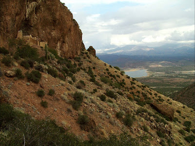
Looking from the upper cliff dwellings at Tonto National Monument down into the Salt River Valley:
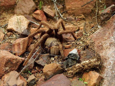
Close encounter with one of the locals:
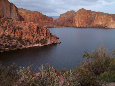
Apache Lake (created by the Salt River Dam) along the Apache Trail:
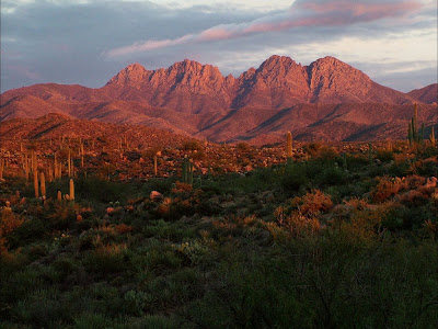
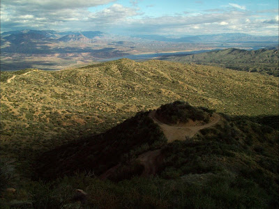
Four Peaks at Dusk
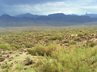
Rain in the Sonoran Desert, Weaver's Needle at the upper right of the photo
View from El Oso Road, on the eastern side of the Four Peaks:
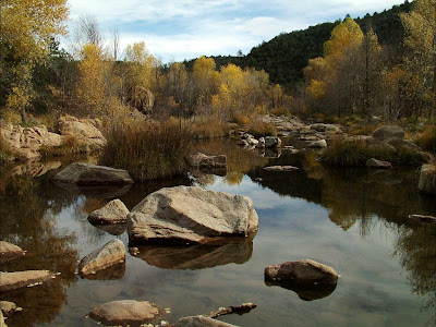
Verde River near Payson AZ
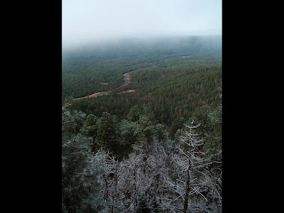
Highway 266 as viewed from the Rim Rod atop the Mogollon Rim, somewhere east of Strawberry AZ
_________________
erstwhile owner of just about every 924 variant ever made |
|
| Back to top |
|
|
|
|
You cannot post new topics in this forum
You cannot reply to topics in this forum
You cannot edit your posts in this forum
You cannot delete your posts in this forum
You cannot vote in polls in this forum
|
Powered by phpBB © 2001, 2005 phpBB Group
|

